- Silverthorne Lodge
- Why Rent Our Silverthorne Townhome?
- Map to Our Silverthorne Townhome
- Check Vacation Rental Availability for Lodge 30A
- Silverthorne Lodge Mountain Cam
- Silverthorne Lodge Reviews
- Silverthorne Lodge Blog
Ski Information
- Breckenridge Snow Report
- Adapt to Elevation Changes
- Tax Deduct Your Ski Vacation
- What to Pack
- Funny Skiing Videos
Things to do in Dillon & Silverthorne
Colorado Hiking Trails
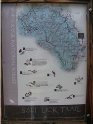
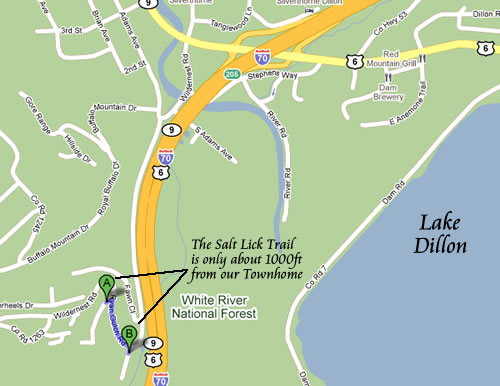
The best Colorado hiking trails are found in Summit County Colorado, and they are in walking distance of the Silverthorne townhome. Use our townhome as your base camp for hiking adventures any time of the year. The entrance of the Salt Lick Trail is only a few hundred feet away. Get dressed in your gear and walk right out the door to begin your hike.
Salt Lick Trail
Colorado is a state synonymous with year round outdoor recreational activities. With its tall snow capped peaks, deep valleys and gorges, numerous hiking and mountain biking trails, outstanding fishing, adventurous water sports and an abundance of flora and fauna, Colorado is the perfect destination for holiday seekers from all over the world.
Colorado is home to some of the most diverse flora and fauna in the country. The lush green forests, the tall aspen and pine trees, the clear blue streams, ponds, lakes and rivers, the dense foliage are an ideal refuge away from the hustle and bustle of the city. Yet, you are never very far from the most modern amenities such as world class ski resorts, restaurants that set standards in culinary excellence and a plethora of shopping options.
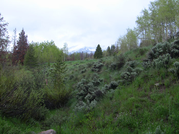 Quandary Peak as seen from Salt Lick Trail |
Every county is Colorado has its own tale to tell from its historical significance to the bevy of recreational activities that it offers. Of the many counties in the state, Summit County is particularly renowned for its myriad of outdoor recreational options, the amazing natural splendor and the luxury and convenience of the various hotels and resorts. Summit county was among the seventeen original counties of Colorado, popularly known as the playground of Colorado, it is perched high in the Rockies. It lies a mere 70 miles to the West of Denver and boasts of a wide array of bicycle routes, hiking trails, scenic byways, national forests, cities and towns.
At the heart of Summit County lies its largest town, Silverthorne. Popular for its bustling shopping centers and other tourist areas which stand in stark contrast of the serenity of the wilderness that surrounds the town. Silverthorne and the surrounding counties all have a dense network of hiking and mountain biking trails which can often also be used as skiing trails in winter. Among the more popular trails of Silverthorne is the famed Salt Lick trail. The trail itself is 4 miles long with an addition of one mile if you continue to Lily Pad Lake and is ideal for beginners with an elevation gain of approximately 650 ft. The trail is well known for its carpet of golden aspen leaves in autumn, the lush dense foliage of the tall pine and aspen forests and the breathtaking view of the mountains.
To get to Salt lick trail you will have to take Exit I-70 at Silverthorne, from here, drive on route 9 to reach Wildernest Road. You should see Wendy’s right across Wildernest Road; turn left on the road and drive on for another 9 miles. This should bring you to a left turn that will lead you to a dirt road that lies on a sharp curve close to the Conoco station (Wildernest Center). You will find car parking here so you will be able to follow the road on foot to the trailhead. Or if you want to take it really easy you can stay in our Silverthorne Townhome and simply walk a couple of hundred feet to the start of the trail.
Once you are at the trailhead, walk for about 15 minutes, and on your left, you should see the log bridge that crosses Salt Lick. If you cross the bridge and continue up the trail you will soon come to the beaver ponds and the open meadows that lie beyond it. At this point you should see a sign that signals the beginning of the Eagles Nest Wilderness Area. Even if you miss this bridge, there is another one a few yards ahead. However, you have to take one of the bridges to cross the Salt lake creek because if you continue up the path without crossing over one of the bridges, you will get out of the trail and enter a subdivision of condos and away from the Salt Lick trail. Beyond the bridge lies the most breathtaking view of tall willowy pines and aspens. If you hike on the trail in fall, you can witness the gorgeous palette of the colors of autumn with a naturally lush yellow carpet of aspen leaves covering the ground. The early morning blue sky, the peaks peeping from in between the trees, the serenity and peace all contribute to a one of its kind hiking experience. As you enter the Eagles Nest Wilderness Area you will have to hike up a steep ascent that will take you to a thick aspen and pine forest till you come up on the junction of the Lily Pad lake Trail.
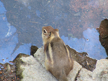 This chipmunk on the Salt Lick Trail let us get close for a picture before running away |
If you choose to continue, the Lily Pad Lake is about half a mile away. Fall is the best time of the year to hike on this trail with its spectacular aspen scenery. Moose sighting have been reported on the Salt Lick Trail so keep your camera handy and if you have kids along don’t let them stray away from the trail. You should also see lots of chipmunks and woodpeckers.
Salt Lake Trail
If you are an avid hiker and the 4 mile stretch of the Salt Lake trail is not enough to whet your appetite you can take the Meadow Creek trail to the salt lick loop and continue on the Salt lick Trail from there. This should add a good 5 miles to your hike.
The Meadow Creek trail is renowned for affording visitors a glimpse of the famed Colorado landscape, complete with mining ruins, view of three famous peaks, Peak One, Torreys and Grays and the towering aspens. The trail has an elevation gain of about 700 feet which makes it appropriate for beginners.
To reach the trail start your journey on the I-70 West and take the Frisco exit 203. As you come up on the traffic circle you should see a dirt road that leaves the circle to the west. The dirt road parallels the interstate and is fairly easy to spot. Just continue driving for about half a mile and you should come up at the Meadow Creek Trailhead and the parking area. Remember that this trail is a good 5 miles one way so you would essentially be hiking for a total of 14 miles including the Salt Lick trail. So, this trail is perfect to get you ready for some of the more challenging hiking trails in the area or if you intend to scale one of the fourteeners.
The climate is nice and warm in July and August and the trail has a steady ascent of about half a mile till you reach the junction of the Lily Pad Trail. Before you reach the junction you will be greeted by an old mine shoot reminiscent of an era gone by. From here take the Lily pad Trail which should be on your right and if you continue walking, you will be able to witness the spectacular sights and sounds of the Meadow creek, the great vistas of Frisco and a footbridge that crosses over the creek.
You will also be able to see the clear blue waters of Lake Dillon and the two fourteeners Grays and Torreys along with a blanket of cloud formations that you will see around midday. Continue ascending on the trail and the vistas just get prettier and better. If you look to the south of the trail you should see Peak One towering over Mt Victoria and Royal.
Once you are past the creek you will find a brief ascent that leads to the first of the two Lily Pad lakes. Continue on the trail after enjoying the lush vegetation and the wild flowers around the first lake to the second lake which is hardly more than a pond with hundreds of lilies floating on the water. This is a great picnic spot which can be reached through the Meadow Creeks Trail (the longer route) or the Salt Lick Trail. Continue past the second lake for about half a mile and you will come up on the Salt Lick Trail junction.
From here the trail descends down to the Salt Lick Gulch. At the bottom of the gulch you should see the footbridge that crosses over Salt Lick Stream; to your left. If you cross the stream and continue, you should come up to the Salt Lick Trailhead. Now if you don’t feel up to the task of hiking another 7 miles to get to your car, walk past the Salt lick trailhead to the Ryan Gulch Road. If you cross the road and take the right you will be right across the Windernest Center at the Summit Stage stop. You can take a free lift from here to the Frisco exit 203 and to your car; the summit stage runs every half an hour so you won’t have to wait long.
Colorado Hiking Trails in the winter
The Salt Lick Trail is not only stunning in spring and fall with its bounty of colorful foliage and wild flowers but it is equally spectacular when snow covers the ground in winter making it perfect for inexperienced skiers. This trail is particularly popular among the snowshoers and Nordic skiers from the Silverthorne and Dillon areas. There are no snow mobiles or mechanized vehicles on this trail because it leads to the Eagles Nest Wilderness area. The trail with its cover of soft packed snow and tall aspen, pine and spruce trees is ideal even for the most inexperienced skiers and snowshoers. From the Salt lake trail you can continue to the Lily pad lake trail with its gentle grades and a fantastic view of the meadows from in between the stands of aspen, pine and spruce to the frozen lakes with its pristine blanket of ice, the spot is ideal for an afternoon picnic.
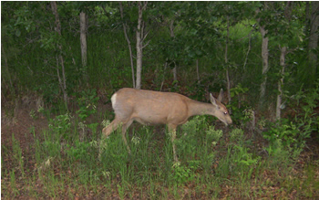 A Salt Lick Trail doe grazes the cool summer grass |
The Salt Lake Trail is not the only path that leads to the Lily pad Lake; there are two other routes that lead to the lakes in the Eagles Nest Wildernesss Area. However, the Salt Lake trail is by far the most scenic route to Lily Pad Lake. But, just before you reach the lakes the trail becomes steep. Even though snowshoers should have no problem, nordic skiers may have to take climbing skins along. The area receives a fair amount of exposure and is at a low elevation so this route is at its best in February and early march when the snow is tightly packed and deep.
Colorado Mountain Biking
Salt lake Mountain Bike trail is a stretch of 1.5 miles at the wilderness boundary. There are many fine and scenic single tracks in the area and its worth exploring if you can connect to the Frisco exit.
Hiking Trails near Salt Lick Trail
Lily Pad Lake
Lily pad Lake Trail, a 3.2 mile hike, is perfect for inexperienced hikers and nature enthusiasts alike. People of all ages including children can enjoy the scenic beauty of this path. The trail starts with a steep ascent but don’t let this dissuade you from exploring the marvelous scenery that lies ahead. Once you cross the initial short climb, the rest pf the path only has mild ups and downs. At the beginning of the trail the road is fairly wide but as you move on you will come up on the water tower, from here the vegetations starts getting denser and the trail narrows down. However, you will experience the true natural beauty of Summit County here, the well shaded forest, spectacular foliage and some of the most diverse flora and fauna in the region. If you forget to get your camera along you will miss out on the opportunity to capture some memorable photographs of Mother Nature is all her glory. The trail is a veritable treasure trove of different wild flower species like the Leafy Cinquefoil and the Heart leaved Arnica.
This is the most perfect destination to introduce children to the pleasures of hiking, they will marvel at the numerous beaver ponds that are scattered across the area and the hundreds of yellow lilies that turn into a yellow blanket covering the Lower Lily pad Lake by mid-summer.
The best part is that the trail is very well marked which makes hiking here hassle-free. Coupled with the gentle slopes and ascents you will find some marshy spots as well, which turn into a breeding ground for mosquitoes in warm weather, so you may want to carry some mosquito repellant along if you intend to hike in summer. There have also been reports of elk and moose sightings on the trail so if you have children along, keep them close.
This path has a long standing history to its credit; it started of as a trail for the 19th century fur trappers. So when you meander among the willowy aspen and pine trees you are indeed walking in their foot steps, so to speak.
As you walk on you will come across log bridges, streams, waterfalls and groves of pine and aspen. Towards the end of the trail you will come across two alpine lakes, one of these lakes is almost a pond teeming with yellow lily blooms and is a sight to behold.
Mesa Cortina Trail
The Mesa Cortina Trail is a little over 2.6 miles one way making it a 5.2 mile hike (two ways). Again, this trail is suitable for beginners with an elevation gain of just 400 ft making it ideal for hikers of all ages. The trail is famous for the gorgeous lush forest of lodge pole and aspen, green meadows of sage brush, the crystal blue waters of Lake Dillon and a spectacular view of the William Fork Mountain and the Ptarmigan peak.
To get to the Mesa Cortina trail start on the I-70, like for all other trails, and drive on Colorado 9 which lies to the north of the Silverthorne exit 205. The directions are almost the same as those for getting to the Salt Lick Trail. Once you spot a Wendy’s outlet to your right and a 7-11 to your left, turn left on the Wildernest Road. This should bring you to mountainous road where Wildernest Road turns to Ryan Gulch Road.. You should see Buffalo drive to your right, take a right here and drive to the end of the road. The dead end of the road is the Buffalo Mountain Drive, take a right here and then a left to get to the Lakeview drive. Soon you will come up on the Aspen Drive intersection; take a left on Aspen drive and you should see a parking lot and the trail ahead to your right.
One of the reasons for the popularity of the Mesa Cortina trail is its year round appeal, regardless of your age, level of experience or the season; this trail has something to offer to all hikers. From the tranquility that envelopes the area as the pristine blanket of snow covers the ground, to the chirping of the birds and the wild flowers in all their bloom in spring and the rich golden blanket of aspen in autumn; there is simply one word to describe this trail, ‘stunning’.
The first half an hour of the walk is fairly easy with a brroad path and very few and gentle ups and downs but then you come up on the most difficult part of the road where you have to climb through a series of switchbacks to traverse the forest. But this road does give you the opportunity to enjoy spectacular glimpses of the towering William Forks Mountains; their spectacular snow capped peaks in winter are a joy to behold. You also get an almost unhindered view of Lake Dillon to the south. Ideally, you should carry a map of the Summit, Vail and Holy Cross trail map to identify the various landmarks that you will cross on the Mesa Cortina Trail.
After hiking for a little over 2 miles you will come up on an old ranching road that merges with the trail on your right. If you hike for another half mile you will reach the crossing of South Willow Creak; over here you will see a sign that announces the merger of the Mesa Cortina Trail with the Gore Range trail. There are several points on this trail that provide an ideal setting for a leisurely picnic brunch or lunch before you head back to the trail head.
Ptarmigan Trail
This trail is particularly famous for its breathtaking view of the majestic mountain ranges and peaks in the area. To get to the trail drive to Route 9 after taking the I-70 to reach the Silverthorne Exit 205. From the Wendy’s outlet turn right at the next stop sign and drive on for less than half a mile past the hotels on your right and you should come to road 2021. A little less than a mile ahead you should see the parking area and the trailhead. Cross over to the other side of the road from the parking area to begin the trail.
The Ptarmigan trail is renowned for the breathtaking view of Peak One, the Ten Mile Range, Willow Peak, Buffalo Mt, Gore Range, Red Peak, Lake Dillon and the Ten Mile Canyon. This trail is ideal for beginners with an approximate elevation gain of 990 feet. The two way trip should be approximately 4.2 miles and is a must do adventure for fall. If you happen to be in Summit County in autumn you simply should not miss the opportunity to see the spectacular reds, yellows misled with the greens of autumn and the beautiful lush carpet of the golden yellow aspen leaves.
Once you cross the road from the parking area to reach the trailhead, you will soon come up on a dry sagebrush mound and from here the trail ascends till it reaches a lush and dense aspen forest. As you continue your ascent you will be able to get the most fascinating view of Lake Dillon, the Gore range across route 9, Buffalo Mt and Red peak.
Through out the hike you will be surrounded by a pretty aspen and pine forest which adds a degree of cushioning to the trail because the path is covered with mulch and pine needles.
You are heading towards a lookout that will give you a bird’s eye view of the peaks, valleys, mountain ranges and forests in the area. If you continue meandering through the forest, you will come up on two streams the second stream is very close to the look out and it shouldn’t take you more than two to three minutes to get to the lookout from here.
From the lookout you will have the trail turns into a steady and steep ascent towards Ptarmigan Peak where you reach an elevation of 12,500 feet. This hike can be further extended by another 2.4 miles. Once you cross the lookout point at about 11,800 feet you will come across an intersecting trail to your right continue on this path to the summit and you should be able to see the two fouteeners Grays and Torreys towering over the area.
But if you are in the mood for something that will get your adrenalin pumping, this next trail will be ideal for you.
Buffalo Mountain
This trail is famous for its stunning vistas, a plethora of wildlife and of course, the sheer joy of being on the Buffalo Peak. Through this hike you will cover a distance of 5.25 miles and the elevation gain is about 3000 feet which puts this trail in the ‘for experienced hikers’ category.
To get to the trailhead take Colorado 9 north to reach the traffic light at Wendy’s. Now turn to the Wildernest Road to your left in front of the 7-11 and drive on for another three and a half miles to reach the final loop where the Wildernest Road turns into Ryan Gulch Road. You should see a parking area to your left at the top of the loop and the trail begins across the road.
This hike is quite challenging and may take the entire day but you will certainly have the satisfaction of scaling one of the most distinguishing landmarks of Summit County. Even though there have been some improvements in the trail in recent years it still remains rocky and steep. You start by ascending through a dense pine forest that leads to the Eagles Nest Wilderness area. From here if you continue walking you will come up on the junction from where you can take the Buffalo Cabin trail that will be to your left. After hiking for about half a mile on this path you should come up on the ruins of some cabins that date back to the early nineteenth century.
Now, the most precarious part of your journey lies straight ahead from here. After you cross a dozen or so switchbacks you will reach the edge of the treeline that will part to reveal a seemingly endless boulder field. Ascending up the tundra will take you to the summit but there is a reward for all the hard work that you are putting in, you will be able to witness the most charming and spectacular view of Lake Dillon.
The summit lies at an elevation of 12,777 feet, once you get there look for the Eccles Pass to your West that will take you down Buffalo’s backyard. It is here that you will find a hidden lake nestled among the rocky cliffs that will make your journey worthwhile. If you are lucky you, may even get company in the form of a family of mountain goats frolicking in the area.
The trek down the summit is as challenging as the ascent so take frequent stops to conserve your energy. On a good day without the famed thunderstorms besieging your trip it should take you three hours to reach the summit and another three hours to find your way down. It is highly recommended that you only take this hike if you have previous experience in finding your way through treacherous terrain.
The Flora and Fauna of the Area
The surrounding of these three trails and Summit County in general, with a great range of elevation, provides the perfect habitat for a myriad of plant species. The variety of vegetation is categorized into five zones: the plains, the foothills, montaine, subalpine and alpine. While the plains abound in various types of grass and an astounding 500 types of wild flowers, the arid, desert like regions at higher elevations are famous for two dozen varieties of cacti. On the other hand, the foothills stand is stark contrast with fragile wild flowers blooming everywhere and a host of berries, lilies, orchids and lichens while the montaine zone is known for its tall coniferous vegetation. Aspen and Englemann are trees seen commonly in the area right up to the timberline. In 2003, 13 plants species were listed as endangered, this list included three varieties of cacti, the Colorado Butterfly plant, two species of milk-vetch and the Penland beardtongue.
The fauna of the region is equally diverse with the mountain goat being the most commonly sighted animal along with elks and moose. The state of Colorado is home to 113 sport-game species and a stunning 747 non game wildlife species. Among the big game species are the Rocky Mountain bighorn sheep which is also the state animal, elks, black bear, antelope, mountain lion, moose, white tailed, mule deers and the mountain goat. The mountain goat and the moose are the only non native big game species. Sightings of lark bunting which is the state bird, morning doves, the blue grouse and almost 28 varieties of ducks makes this an ideal place for bird watchers. Colorado is also a veritable fisherman’s and angler’s paradise with over 100 sport fish species. The scores of lakes and rivers are teeming with kokanee salmon, bullhead and various diversities of trout. Among the rare fauna of Colorado are the wood frog, the golden trout and the white pelicans. The bald eagle and the Mexican spotted owl can also be seen in the area but they are among the threatened species while the whooping crane, the bonytail chub, the gray wolf, the blackfooted ferret, the razorback sucker and the southwestern willow flycatcher are among the endangered species of the area.
The Salt Lick trail is only 1000ft from our Silverthorne Townhome. Use us as your base camp. Put your gear on and walk right out the door to begin your hike!
 |

